| Antique Maps by Thomas Kitchin |
Images |
(Code No. 6070)
Kitchin, Thomas.
(Antique Map).
A New Map of the Isle of Wight. Drawn from Surveys by Tho' Kitchin Geog'.
Date. 1763.
London, London Magazine. Page size (10 1/2 x 8 1/4ins]. Original copper engraved folding map, slight browning.
Thomas Kitchin, (1719-1784) was an English engraver and cartographer. He was born in Southwark, and was apprenticed to Emanuel Bowen in 1732. Originally based in Clerkenwell, by late 1755 Kitchin was established on Holborn Hill. From 1773 Kitchin was appointed royal Hydrographer to the king....... £50.00 |
Click on picture above to view more images
How to order |
| (Code No. 3351)London. A Hogg. Image size 12 x 8 ins. Page size 15 x 9 1/2 ins. 1770.
Original folding copper engraved map from.The New & Complete
& Universal System of Geography. Decorative title cartouche. New
Holland (Australia) showing Tasmania joined to the main land. Ornamental
borders. |
SOLD
|
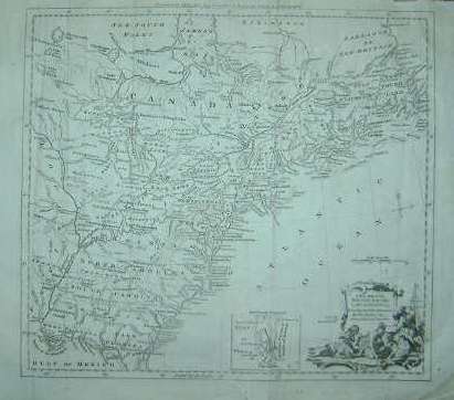
(Code No. 3344)
Kitchin. Thomas,
(Antique Map)
"A NEW MAP OF THE BRITISH EMPIRE IN NORTH AMERICA, DRAWN FROM
THE LATEST AUTHORITIES BY THOs. KITCHIN. GEOR, HYDROGRAPHER TO HIS
MAJESTY"
London: A. Hogg. Image Size 14 1/2 x 13 ins. Page Size 19 x 15 ins.
1782. Original folding copper engraved map. This map covers from Canada
to Florida and from Newfoundland to the West of the Mississippi River.
Compass Indicator. Scale 290 miles to the Inch. Decorative Cartouche.
Inset map of "East Florida Continued" and Graduated border.
Slight split to fold, repaired. £350.00
|

Click to view more images
How to order |
| (Code No. 3350)Kitchin. Thomas. (Antique Map.)A New & Correct Plan of HANOVER, a City in the Circle of
Lower Saxony,and Capital of the King of Great Britain's German Dominions.London. A. Hogg. Image Size 111/2 x 8 ins. Page size 15 x 9 ins. ca1780.Original copper engraved Town Plan by J. Lodge. Showing fortifications,
coat of arms, compass rose, houses and the garden designs and scale
bar.Ornamental borders. |
SOLD
|
(Code No. 3347)
Kitchin. Thomas, (Antique Map).
SOUTH AMERICA agreeable to the most approved Maps and Charts.
London: A. Hogg. Image Size, approx 14 1/2 x 13 ins. Page Size 19
x 15 ins. 1782. Original folding copper engraved map, from Millar's
Universal Geography. Decorative title cartouche Includes a native
American and animals etc. Graduated border. £90.00
|
Click to view more images
How to order |
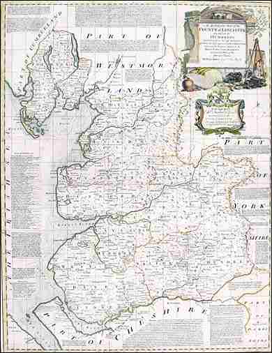
(Code No: 2817)
BOWEN, EMMANUEL & THOMAS. KITCHIN. (Antique Map of
LANCASHIRE.)
"An Accurate Map of the County of LANCASTER; Divided
into its Hundreds"
London. Carington Bowles & Rob't Sayer. 1767. Map image size
20 1/2 x 26 ins . Copper engraved, coloured in outline, county map
by Eman: Bowen. Title panel with a pictorial surround which includes
cheeses, a woman shovelling grain into a sack held by a man and
another man stoking a furnace, etc, with a Heraldic coat of arms
below (Stanley Earl of Derby). A notable feature of the map is the
space devoted to descriptive text in the form of the major town
historical notes, "Seats of the Nobility" and "Explanation"
(of the symbols on the map), spread over the map surface. Circular
compass indicator, scale line and coloured graduated border, slight
splits to folds, (No loss). The map is taken from the "Large
English Atlas" Guaranteed to be over 200 years old. £375.00 |

Click to view more images
How to order
|
| (Code No.DP
3185)Kitchin, T. (Antique Map.)SURREY. Drawn from an Actual Survey and regulated by Astronomy,
Observed by T. Kitchin.London. Alex. Hogg. 1795. Page size 15 x 9 ins. Image size 8 x
6 1/2 ins. Copper engraved map by T.Kitchin. From Antiquities of
England and Wales by Captain Grose. Guaranteed to be over
200 years old. |
SOLD.
|
| (Code No.DP 3188)Kitchin, T. (Antique Map.)SUFFOLK. Drawn from an Actual Survey and regulated by Astronomy,
Observed by T. Kitchin.London. Alex. Hogg. 1795. Page size 15 x 9 ins. Image size 8 x
5 1/2 ins. Copper engraved map by T.Kitchin. From Antiquities of
England and Wales by Captain Grose. Guaranteed to be over
200 years old. £50.00 |
SOLD.
|
| (Code No. DP
3190)Kitchin, T. (Antique Map.)ESSEX. Drawn from an Actual Survey and regulated by Astronomy,
Observed by T. Kitchin.London. Alex. Hogg. 1795. Page size 15 x 9 ins. Image size 8 1/2
x 10 1/2 ins. Copper engraved map by T.Kitchin. From Antiquities
of England and Wales by Captain Grose. Guaranteed to be
over 200 years old. |
SOLD.
|
(Code No. DP 3191)Kitchin, T. (Antique Map.)MIDDLESEX. Drawn from an Actual Survey and regulated by
Astronomy, Observed by T. Kitchin.London. Alex. Hogg. 1795. Page size 15 x 9 ins. Image size 8 1/2
x 10 1/2 ins. Copper engraved map by T.Kitchin. From Antiquities
of England and Wales by Captain Grose. Guaranteed to be
over 200 years old.
|
SOLD.
|
Return to top
|