SITE CONTENT
Antique Maps & Prints
Britain
Antique Maps - World
Antique Books
Cartographers
Early Prints
Other Stock
|
| Maps,Prints & Books of Australia & NZ |
Images |
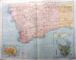
(Code No. 6858)
Gross, Alexander.
Australia .South West.
(Antique Map).
Date. [c.1900].
London, Geographia Ltd. Large folio. Image size [18 x 23ins.] . . Original coloured engraved map by A. Gross, with small inset maps ofTasmania & Australia (rainfall).. Very good condition........ £45.00 |
Click on picture above to view more images
How to order |
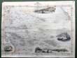
(Code No. 6810)
Tallis, John.
[Antique Map.]
Polynesia, or Islands in the Pacific Ocean.
Date. (c.1850}.
London. J & F Tallis. Page size, [15 x 10). Original steel engraved map with original outline hand colouring. 4 vignette views.Kalakakoa Bay, site of Cook's death, Otahiti, Harbour of Doree New Guinea and Resolution Bay, Marquesas. Decorated border, centre fold, Slight nicks to to outer edges, one nick, approx, (1/2ins). John Tallis' maps are the last decorative, regional maps to be published....... £45.00 |
Click on picture above to view more images
How to order |
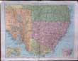
(Code No. 6784)
Gross, Alexander.
Australia . South East.
(Antique Map).
No date. [c.1900].
London, Geographia Ltd. Large folio. Image size [18 x 23ins.] Original coloured engraved map by A. Gross, with small inset maps of Melborne District & Sydney District. Very good condition........ £45.00 |
Click on picture above to view more images
How to order |
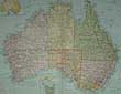
(Code No. 6666)
Gross, Alexander.
Australia (Political).
(Antique Map).
No date.[c.1900].
London, Geographia Ltd. Large folio, [18 x 23ins.] Original coloured engraved map by A. Gross. Small inset maps of Tasmania and population density map of Australia. Very good condition ........ £45.00 |
Click on picture above to view more images
How to order |
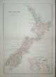
(Code No. 6581)
Weller, E.
(Antique Map).
New Zealand.
Date. [c.1880].
Edinburgh. Blackie & Son.. Page sizes, [22 3/4 x 16ins]. Double page colour printed map, including an inset plan of the "Environs of Auckland".
Listing:- Auckland, New Plymouth, Wellington. Maori, Cook Straight, Canterbury, etc, very good condition..... £40.00 |
Click on picture above to view more images
How to order |
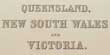
(Code No. 6577)
Bartholomew, John & E. Weller.
(3 Antique Maps).
3 Australian Engraved Coloured Maps.
Date. [c.1880].
Edinburgh. Blackie & Son.. Page sizes, [22 3/4 x 15 1/2ins]. 3 Double page colour printed maps :- Australia and New Zealand - The Pacific Ocean - New South Wales, Queensland, and Victoria, nicks to outer edges well away from printed maps....... £45.00 |
Click on picture above to view more images
How to order |
(Code No. 6163)Brassey, Mrs Anna.A Voyage in the 'Sunbeam.Our Home in the Ocean for Eleven Months.Date. 1880.London, Longmans Green and Co. 8vo Pp. xix, 492, slight foxing + Folding coloured map + Illustrations throughout. Original gilt decoration, slight rubbing....A Voyage in the Sunbeam, describing their journey around the world in 1876-7, ran through many English editions and was translated into at least five other languages. Her accounts of later voyages include Sunshine and Storm in the East (1880) In the Trades, the Tropics, and the Roaring Forties (1885); and The Last Voyage (1889, published posthumously)......
|
SOLD.
|
(Code No. 6112)Chandris Line.Chandris Line. R.H.M.S. "ELLINIS" Berthing Plan.Date. October 1966.London. Page plan size [22 x 35ins] Date. Folding blue page accommodation and berthing plan for the Chandris Lines. RHMS Ellinis. slight nicks to outer edges.Ellinis made regular line voyages to Australia, as well as operating occasional cruises. For several years in the late sixties early seventies she was employed on an eastward round-the-world service sailing via the Suez, or South Africa, to Australia, New Zealand via the Panama to New York to Britain or directly to Rotterdam or Bremerhaven. On December 3, 1986 she departed Perma under tow bound for the breakers, however she commenced taking on water not far from Singapore on March 11, 1987 and slowly developed a 15 degree list to starboard. However they managed to rectify the problem and the tow continued and she arrived in Kaohsiung on April 15, 1987 and it is said that breaking up commenced about two months later........
|
SOLD.
|
(Code No. 6063)CHANDRIS LINES,Cruise Accommodation Plan R.H.M.S. "AUSTRALIS" One Class - Fully air Conditioned. CHANDRIS LINES, Okeania S.A.Date. [c.1960].Page size, [21 x 30ins]. Original folding deck plan for R.H.M.S. "AUSTRALIS", very good condition.R.H.M.S. Australis was purchased from the United States Lines, she entered service with Chandris Line in August 1965, joining Ellinis on the UK-Australia service. The Australis particularly proved to be an extremely popular ship on the run from United Kingdom to Australia, usually operating at full capacity.......
|
SOLD.
|
(Code No. 5986)7 Australian Engraved Coloured Maps.Date. [c.1896].Edinburgh. The Office of the Times. Page size, [22 3/4 x 17 3/4ins]. 7 Double page colour printed maps.Australia, South Wales, Eastern Queensland, New South Wales, Victoria and Tasmania, Australia - Eastern Section and Australia Western Section by John Bartholomew. Scale :- 1 : 6,000.000. 1 : 2500.000 and 1 : 10,000,000. very good condition.......
|
SOLD.
|
(Code No. 5973)Moulton, J. Egan. with the Co-operation of W. Fiddian Moulton.Moulton of Tonga.Date. 1921. London, Epworth Press. 8vo, [8 x 5 1/2ins].Pp 169 + Portrait frontis + Illustrations. Original cloth gilt. Dust jacket,chipping to edges. Dr Egan Moulton laboured for forty years in the Friendly Islands, and was one of the most striking personalities in Australasian Methodism.....
|
SOLD.
|
(Code No. 5912)COOK, Captain James.- Captains Portlock, Carteret, Wallis, Douglas, Saugnier, Rochon, Bligh, Edwards, Wilson, Lutwych, Anson, Drake, Bruce, Hodge, Patterson, Macartney & Wallace.Date. [c.1800].A Compilation of Travels and World Voyages. London, Folio, [10 x 15ins]. Pp. (approx) 800, (the pagination is not consecutive through the volume) + 41 Full page copper engraved prints + 12 Full page copper engraved maps/charts, trimmed closely, some light browning and staining, no list of contents, sold as is.Listing voyages to - Tahiti, New Zealand, Van Diemen's Land, America, Africa, India, Canada, etc. Original half calf gilt with raised spine bands, leather loss & leather hinge splits. Holding firm........
|
SOLD.
|
(Code No. 5891)Tallis, John.[Antique Map.]POLYNESIA.Date. [c.1850].London. J & F Tallis. Page size, [15 x 10 1/2ins]. Original steel engraved map with original outline hand colouring. 4 vignette views. Decorated border, centre fold, vg. John Tallis' maps are the last decorative, regional maps to be published.......
|
SOLD.
|
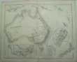
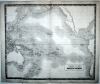
(Code No. 5827)
Swanston, G. H & A. Fullarton.
( Antique Map.)
AUSTRALIA and NEW ZEALAND.
Date. 1860.
London & Edinburgh. A. Fullarton & Co. Image Size 20 x 16 ins. Page size 22 1/2 x 18 1/2 inches. Original steel engraved map with outline hand colour by G.H. Swanston, split to fold just into engraved area.
Showing inset maps of, Victoria and the adjoining Regions, Goldfields of Mount Alexander and New South Wales. Listing the Counties of New South Wales, Western Australia, Victoria and the Police Divisions........ £65.00 |
Click to view more images
How to order |
(Code No. 5818)Bryhn, B.J. & T. Schyberg & O.T. Oestmoen.Round the World with 'Ho-Ho.Date. 1953.London, Geoffrey Bles. 8vo, Pp, 205, + 19 illusrations. Original cloth gilt. Dust jacket, frayed edges......
|
SOLD.
|
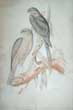
(Code No. 5396)
GOULD, John and RICHTER, H. C.
(Antique Australian Bird Print.)
Accipiter Torquatus [Collared Sparrow Hawk].
Date. 1840-48.
London, Hullmandel. Page size [14 x 22ins.] Original hand-coloured lithograph, (mounted), splits to edges, affecting title not affecting image, faded. Taken from John Gould's "Birds of Australia"... £110.00 |
Click to view more images
How to order |
(Code No. 5258)Churchouse, Jack.The Pamir. Under the New Zealand Ensign.Signed by the author.Date. 1978.Wellington, NZ, Millwood Press. Folio, [8 1/2 x 11 1/2ins.] Pp. xi,284. Illustrated throughout, very good condition. Original cloth gilt. Dust jacket, nicks to edges and creases.
|
SOLD.
|
| (Code No. 4978)Reid, George Houstoun.An Essay on New South Wales, the Mother Colony of the Australias.Date. 1876.Sydney: Thomas Richards. 8vo, [7 x 10ins.] 1876. Pp. vi, 173, [1]. 2 library stamps only, title & pp.1 + Folding panorama view of Sydney and Port Jackson in 2 parts, (as issued), (size 66 x 10ins) + Map, repaired, no loss + Folding table. Original cloth gilt, slight fading & chipping to corners.
|
SOLD.
|
| (Code No. 4831)Illustrated guide of the Orient line of steamers between England & Australia / issued on behalf of the Orient Steam Navigation Company and the Pacific Steam Navigation Company.Date. [c.1884.]London : F. Green & Co. [and] Anderson, Anderson & Co. Folio, [15 x 11ins.] Pp. [x], 120 + [24 pp. Australian & New Zealand trade adverts], a few nicks to outer edges + [30] leaves of full page lithographic plates. (National Library of Australia's copy calls for [35] leaves of plates). Showing :- 6 Star charts, etc + 6 views + 14 Coloured maps, including 5 of Australia & 1 of New Zealand + 5 Plans. Original half morocco gilt. Worn with surface loss. The book gives a brief description of liners used and a detailed account of the places visited including the history, natural history, etc. The thrust of the guide is for settlement to Australia & New Zealand.
|
SOLD.
|
| (Code No. 4443)Cook, James. Captain .(1728-79).A CHART OF THE ISLANDS DISCOVERED IN THE NEIGHBOURHOOD OF OTAHEITE IN THE COURSE OF SEVERAL VOYAGES ROUND THE WORLD MADE BY THE CAPTNS BYRON, WALLIS, CARTERET & COOK IN THE YEARS, 1765, 1767, 1769.Date. ca1780.London, Alex Hogg. Page size, [15 x 10ins] Original copper engraved chart, crease mark. Shows routes of the three voyages.
|
SOLD
|
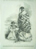
| (Code No. 4439)
Angas, George French.
(2 Antique prints of Maori Chiefs.)
Paratene Maioha, a Chief of Wangaroa, wearing the dog's-skin robe and Munga Kahu, Chief of Roto-aire, with Ko-mari his wife.
Date. ca1840.
London. Page size, 11 x 14 ins. 2 woodcut engraved prints of Maori Chiefs taken from the original drawings from life by George French Angas. £60.00
|
Click to view more images
How to order |
| (Code No. 4401)The Opening of the Adelaide
Jubilee Exhibition, South Australia. Views of the Town of Adelaide
and the Neighbourhood.(Antique Print of Adelaide, Australia).Date.
2nd July 1887.London. The Graphic. Page size 23 x 16ins. Double
page engraved print, showing 11 inset views of Adelaide and
it's neighbourhood. Showing :- Government Offices, Court House,
Public Library, Government house, Viaduct of the Adelaide Railway,
St. Peter's Cathedral, Country scene from Government House, Botanic
Gardens, King William's Street, Port Adelaide Lighthouse and Adelaide
from the Post office looking South-East. £45.00
|
SOLD |
| (Code No. 4369)(Antique Print of New Zealand)Port Lyttelton, New Zealand, with the enterance to the New Graving Dock.Date. 28th April 1883.London. The Proprietors of the I.L.N. Image size 13 x 7 1/4 ins. Page size 16 x 11ins. Original woodcut engraved print by T S. Lyttelton was formerly called Port Cooper and Port Victoria. It was the original settlement in the district (1850). The name Lyttelton was given to it in honour of George William Lyttelton of the Canterbury Association, which had led the colonisation of the area.
|
SOLD.
|
| (Code No. 4265)Melbourne from the Botanical Gardens, Australia.View of Sydney, Australia.(2 Australian Antique Prints.)London Printing and Publishing Co. No Date, ca1850. Page sizes [11 x 7 1/2 ins.] 2 Steel engraved prints taken from the original drawings by W. H. Wilson & H. Winkles. Engraved by H. Winkles & H. Bibby, slight foxing to margins of one print.
|
SOLD.
|
(Code No. 4141)
Johnston, A. K.
( Antique Map.)
ISLANDS IN THE PACIFIC OCEAN.
Edinburgh. W & A. K Johnston. ca1860. Page size 26 x 21 1/2 ins. Original steel engraved map by W & A. K Johnston, nicks to blank margins, not affecting engraved area. £80.00
Tasmania still called Van Diemen Land, |
Click to view more images
How to order |
| (Code No. 4123)Anon.A NARRATIVE OF THE VOYAGES ROUND THE WORLD PERFORMED BY CAPTAIN JAMES COOK'S: With an Acccount of His Life During the Previous and Intervening Periods.London. S. Pratt. 1848.12mo, [3 1/2 x 5 ins]. Pp 320. Engraved frontis + Engraved title, marginal foxing + Additional title, chipping to edges. Dedication to back of frontis. Original cloth, faded.Cook was accompanied on his voyages by many scientists, whose observations and discoveries added to their importance. Joseph Banks, a botanist, went on the first voyage along with fellow botanist Daniel Solander from Sweden. Between them they collected over 3,000 plant species. Banks became one of the strongest promoters of the settlement of Australia by the British.
|
SOLD
|
(Code No. 4073)Tallis, John.Part of South Australia.
[Antique Map.]London. Ca 1850. Size Approx 360 x 275mm. Original steel engraved map with original outline hand colouring. 4 vignette views that includes Adelaide. Decorated border. Centre fold.
|
SOLD
|
| (Code No. 3899)Middleton.(10 Antique Prints + Text.)Captain Cook's voyage to the South Seas.London. A Hogg. ca1780. Image size 7 x 11 ins, (approx). Pp 201-219 (Australia,(New Holland), New Zealand , South Sea Islands Text ) + Original copper engraved plates (10 views on 8 pages), taken from Middleton's Geography , very good condition. Showing:- Exact representation of a Morai or Burial Place in Olaheite, The Mode of Dancing in the Island of Ulietea, Capt' Wallis on his arrival at Olaheite,,,. A view of the New discovered Island of Ulietea..., A view of Olaheite with Several Vessels..., Inhabitants of Amsterdam Island in the South Seas..., A Vari Mancauco native Madagasca, A Remarkable Animal found on one of the Hope Islands..., A
Perspective
view of Cocos and Traitors Island...., A Chief and other Natives of Olaheite visiting Capt' Cook,,,.
|
SOLD.
|
| (Code No. 3878)A Curiously Arched Rock on the Coast of new Zealand & A New Zealand Chief whose head is ingeniously Tatawed and a Subaltern Warrior of the same Country.London. A. Hogg. ca1780. Page size 9 x 13 ins. Image size 7 1/2 x 11 ins. Original copper engraving by Page taken from the original drawing by Sydney Parkinson , foxing to blank margins not affecting image.
|
SOLD
|
(Code No. 3539).New Zealand. Wellington. 8vo [5 1/2 x 8 1/2 ins.] 1903. Pp (8) adverts 1-128 text. 129 -168 adverts, very good. Illustrated throughout. Original pictorial soft covers, slight foxing.
|
SOLD |
| (Code
No. 3431)Wyld. J. (Antique Map)Eastern Hemisphere.London, J. Wyld, Geographer to the King.
Charing Cross East. 1832. Size 23 1/2 x 23 1/2 ins. Image size 22
3/4 x 22 3/4 ins. Copper engraved map of the Eastern Hemisphere
in original outline hand colour , slight water stain to
lower blank margin, vg. Guaranteed to be over 150 years old.
|
SOLD.
|
(Code No. 3295)
London. Blackwood & Son. ca1860. Page sizes 19 1/2 x
24 ins. 2 Steel engraved hand-coloured in outline maps by A.K. Johnston,
Oceania map split to folds (no loss) |
SOLD |
(Code No. 3294)
Australia and New Zealand. (11 Antique Maps)
London. No Dates, ca1900-14. Page Sizes 30 x 22 1/2 ins to 17 1/2
x 23 ins, (approx)11 Coloured Oceania and Australian Maps etc by J.Bartholmew,
(10) and J. Arrowsmith. Maps Shown, Asiatic Archipelago with an inset
map of the Island of Singapore, Victoria and Tasmania, Islands of
Oceania, South Australia, Australia, (Eastern Section), Australia,
(Western Section), Australia, New South Wales, 2 x South Pacific Ocean
and New Zealand, vg. £55.00 |

Click to view more images
How to order |
| (Code No.3011)London. Ca 1850. Size Approx 360 x
275mm. Original steel engraved map with original outline hand
colouring. Three vignette views which includes Hobart Town.. Decorated
border. Centre fold, vg. |
SOLD |
(Code No.3013)
London. Ca 1850. Size Approx 360 x 270mm.
Original steel engraved map of New South Wales, Australia, with
original outline hand colouring. 3 vignette views, which includes
Sydney Cove and Pandanu the Murray. Decorated border. Centre fold,
vg.
|
SOLD
|
(Code No.3016)
London. Ca 1850. Size Approx 370 x 260mm. Original
steel engraved map with original outline hand colouring. 4 vignette
views. Decorated border, Centre fold, vg.
|
SOLD |
Return to top
|
|